(To play the video, please click on the image above)
Image: Bathymetry at the Rodrigues triple junction in the Indian Ocean (bathymetric map 2024 created with GeoMapApp / CC BY / CC BY (Ryan et al., 2009).
(To play the video, please click on the image above)
Image: Bathymetry at the Rodrigues triple junction in the Indian Ocean (bathymetric map 2024 created with GeoMapApp / CC BY / CC BY (Ryan et al., 2009).
This chapter presents some examples of real existing triple junctions on Earth.
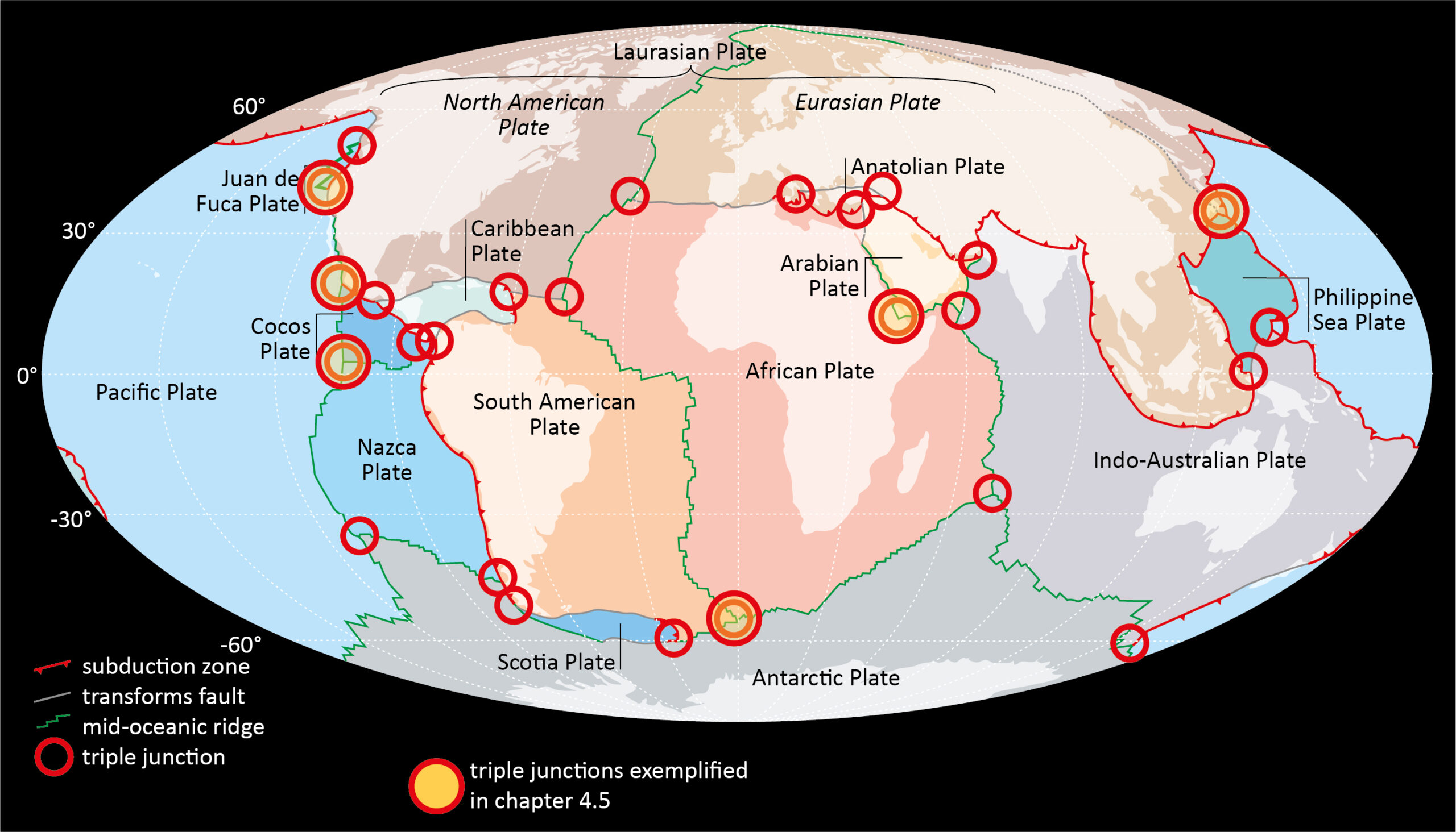
Fig. 4.5.1: Earth’s plate pattern. Highlighted with red circles are triple junctions (modified after Meschede & Warr, 2019)
Figure 4.4.1 shows the Earth’s plate pattern with some triple junctions. If we also count all the small plates, we can assume there are around 50 independent plates today. An inevitable geometric consequence of this large number of plates is that there are lot of triple junctions where three plate boundaries meet. All plate boundaries are dynamic boundaries that are subject to constant change: at divergent plate boundaries the plates move away from each other, at convergent plate boundaries they move towards each other and at transform faults they slide past each other. There are no junctions with four meeting plate boundaries because due to the dynamic development they would be converted back into triple junctions immediately after their formation. The highlighted triple junctions are described in detail below.
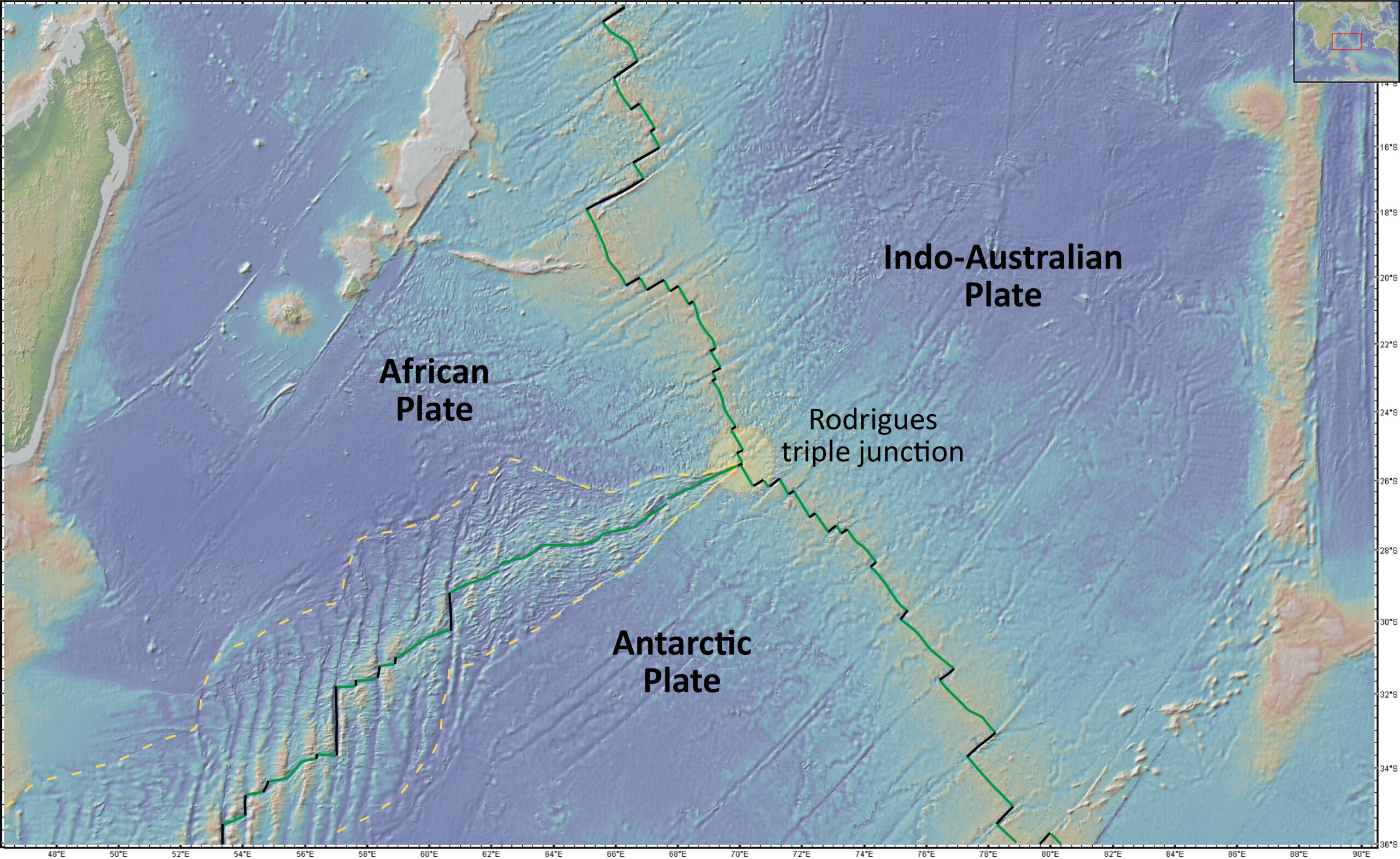
Fig. 4.5.2a: RRR triple junction – example Rodrigues triple junction in the southern Indian Ocean (bathymetric map 2024 created with GeoMapApp / CC BY / CC BY (Ryan et al., 2009).
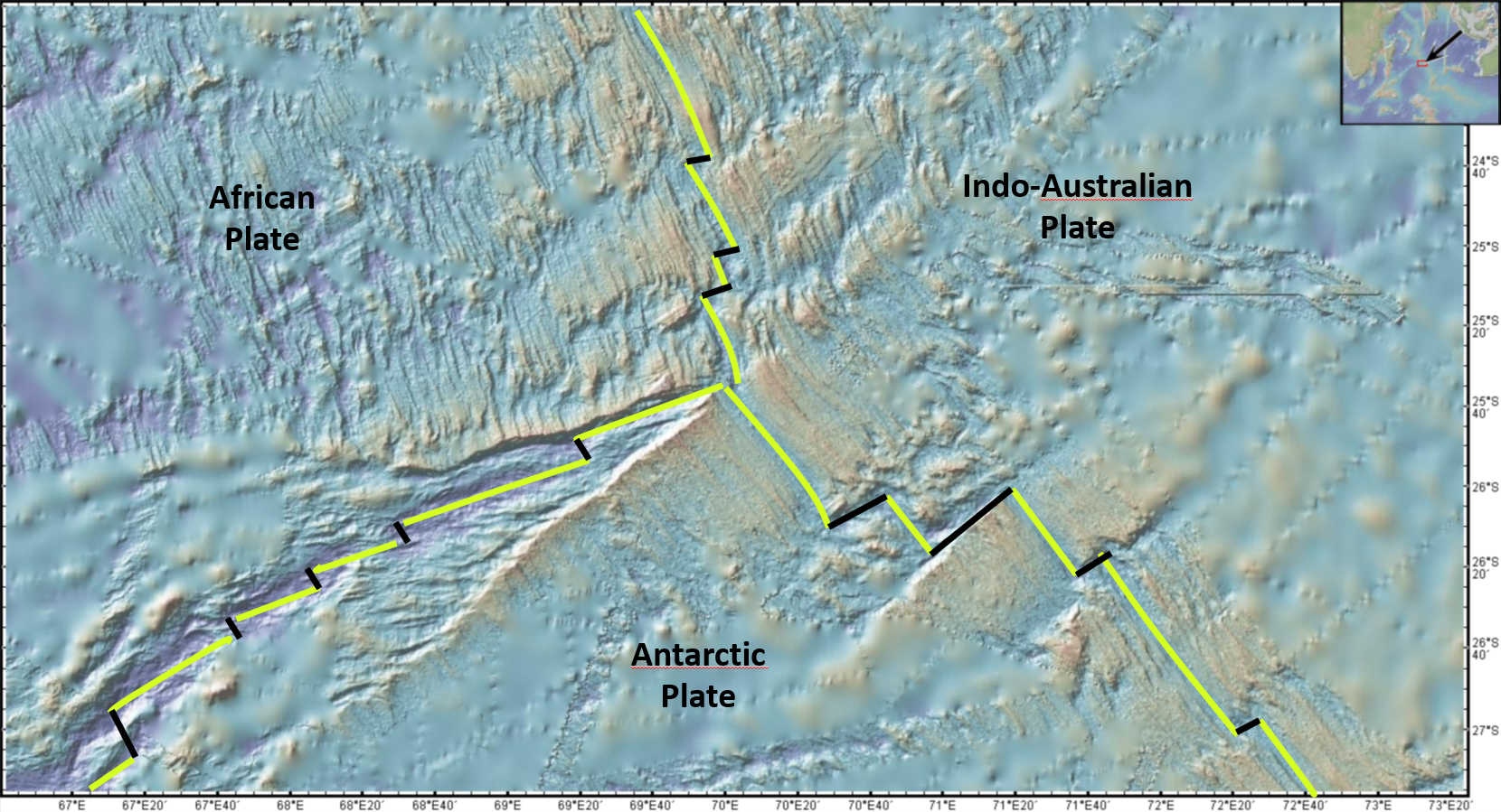
Fig. 4.5.2b: Detailed bathymetric map of the Rodrigues triple junction in the southern Indian Ocean (bathymetric map 2024 created with GeoMapApp / CC BY / CC BY (Ryan et al., 2009).
The Rodrigues triple junction in the southern Indian Ocean shown in Fig. 4.5.2 is an example of an RRR triple junction. Three mid-oceanic ridges meet here. The bathymetric or topographic map (Madagascar can be seen at the top left) shows the morphology of the seafloor. Bathymetric means that the respective water depth is shown in color code on the map. This then results in a map of the seafloor morphology. The lighter the color, the shallower the water depth.
Fig. 4.5.2b shows a section of the map in Fig. 4.5.2a. The Rodrigues triple junction is also very clearly visible in detail and is geometrically simple. The mid-oceanic ridges meet directly at the triple junction, which, however, is not the case at all triple junction: see Fig. 4.5.3b.
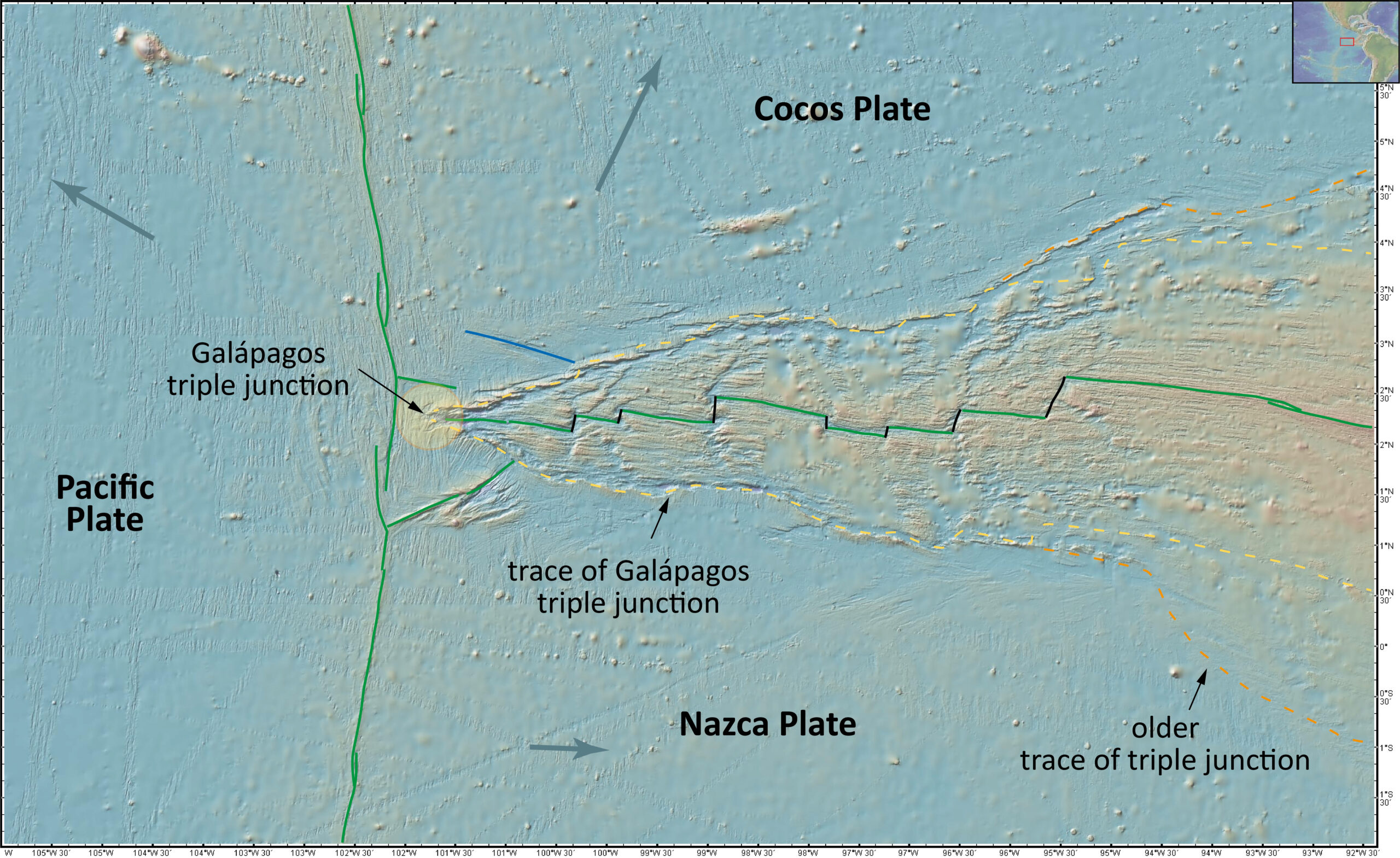
Fig. 4.5.3a: RRR triple junction – example Galápagos triple junction in the Pacific Ocean (bathymetric map 2024 created with GeoMapApp / CC BY / CC BY (Ryan et al., 2009).
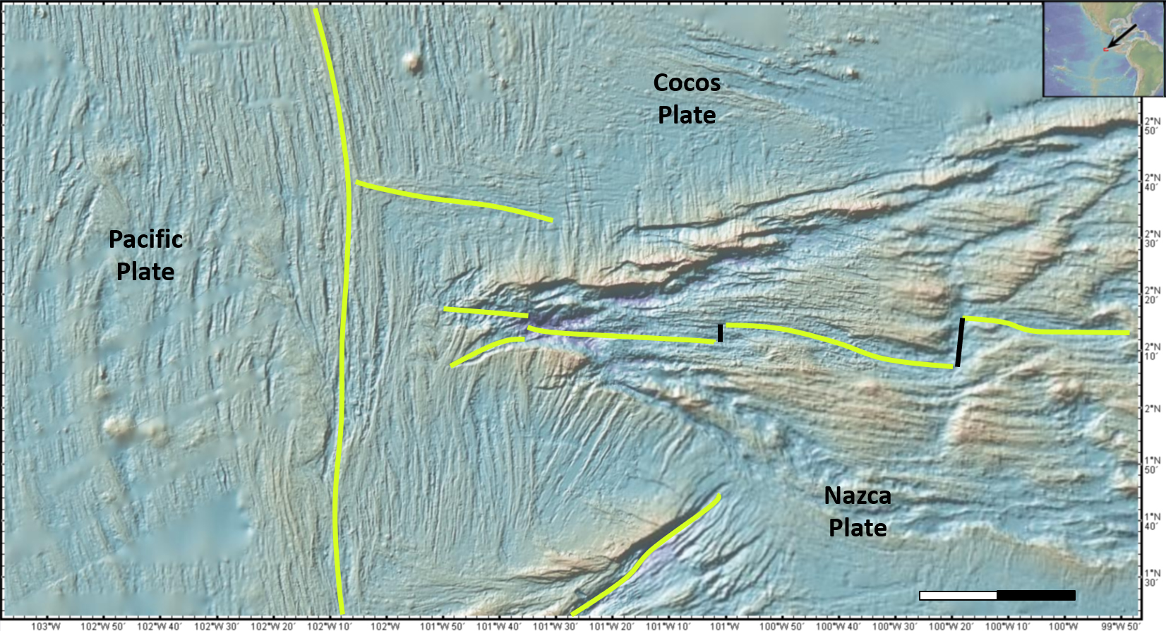
Fig. 4.5.3b: Detailed bathymetric map of the Galápagos triple junction in the Pacific Ocean (bathymetric map 2024 created with GeoMapApp / CC BY / CC BY (Ryan et al., 2009).
The Galápagos triple junction is also an RRR triple junction. In the bathymetric map (Fig. 4.5.3a), the East Pacific Rise can be seen on the left with the narrow thin line and the east-west trending Galápagos spreading system with its somewhat rougher seafloor morphology.
In detail (Fig. 4.5.3b) the Galápagos triple junction is not as clear as at the Rodrigues triple junction. It is not clear from the morphology where the mid-oceanic ridges meet and, especially at the Galápagos spreading center, it is not clear where the ridge trends to extend further to the west. There are two branches to choose from and only the future will show which branch will prevail as a spreading system.
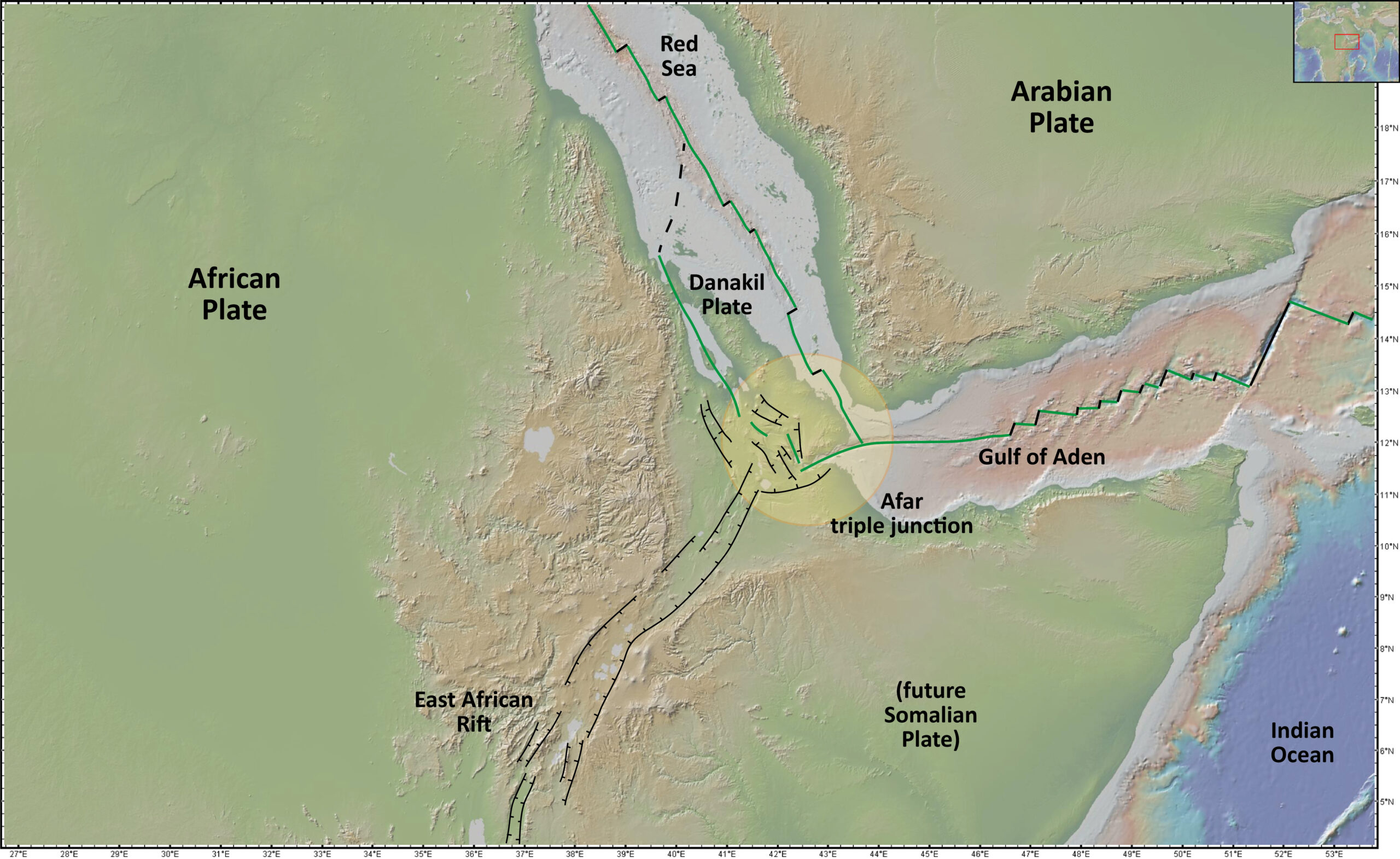
Fig. 4.5.4a: RRR triple junction – example Afar triple junction in the Afar Triangle (topographic/bathymetric map 2024 created with GeoMapApp / CC BY / CC BY (Ryan et al., 2009).
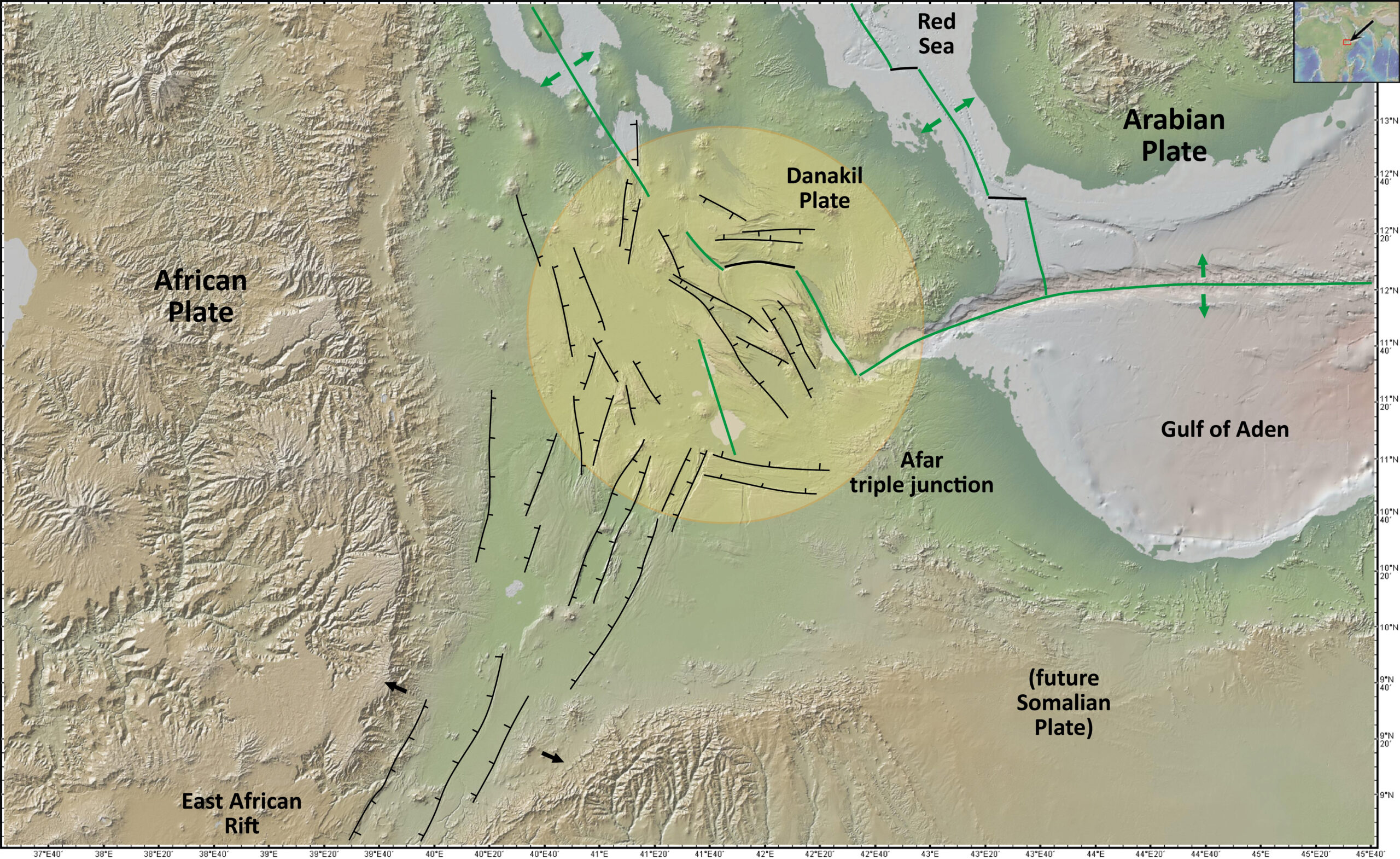
Fig. 4.5.4b: Detailed topographic/bathymetric map of the Afar triple junction in the Afar Triangle (topographic/bathymetric map 2024 created with GeoMapApp / CC BY / CC BY (Ryan et al., 2009).
Fig. 4.5.4 shows a RRR triple junction in the Afar triangle, where the Red Sea, the Gulf of Aden and the East African Rift system meet. It is the triple junction of the Arabian Plate, the African Plate and the Somalian Plate. The Somalian Plate, however, is not yet completely separated from the African Plate (see Chapter 3.1 of the series on the Earth system).
The Afar triple junction is far more complicated than it first appears from a distance. The East African Rift system comes in from the bottom left, a mid-oceanic ridge, however, has not yet been developed there. The graben structures meet very young spreading zones in which new oceanic crust is already forming, but which are not yet clearly defined. In addition, a small microplate has formed in the area of the Afar Triangle, which is called the Danakil plate – after the Danakil depression in the middle of this plate. The boundaries of the plate are not entirely clear, but since it is surrounded on all sides by plate boundaries, it is now considered as a microplate in terms of plate tectonics.
There are therefore several triple junctions in the Afar Triangle, because there are also triple junctions with the Danakil microplate wherever three plate boundaries or future plate boundaries meet.
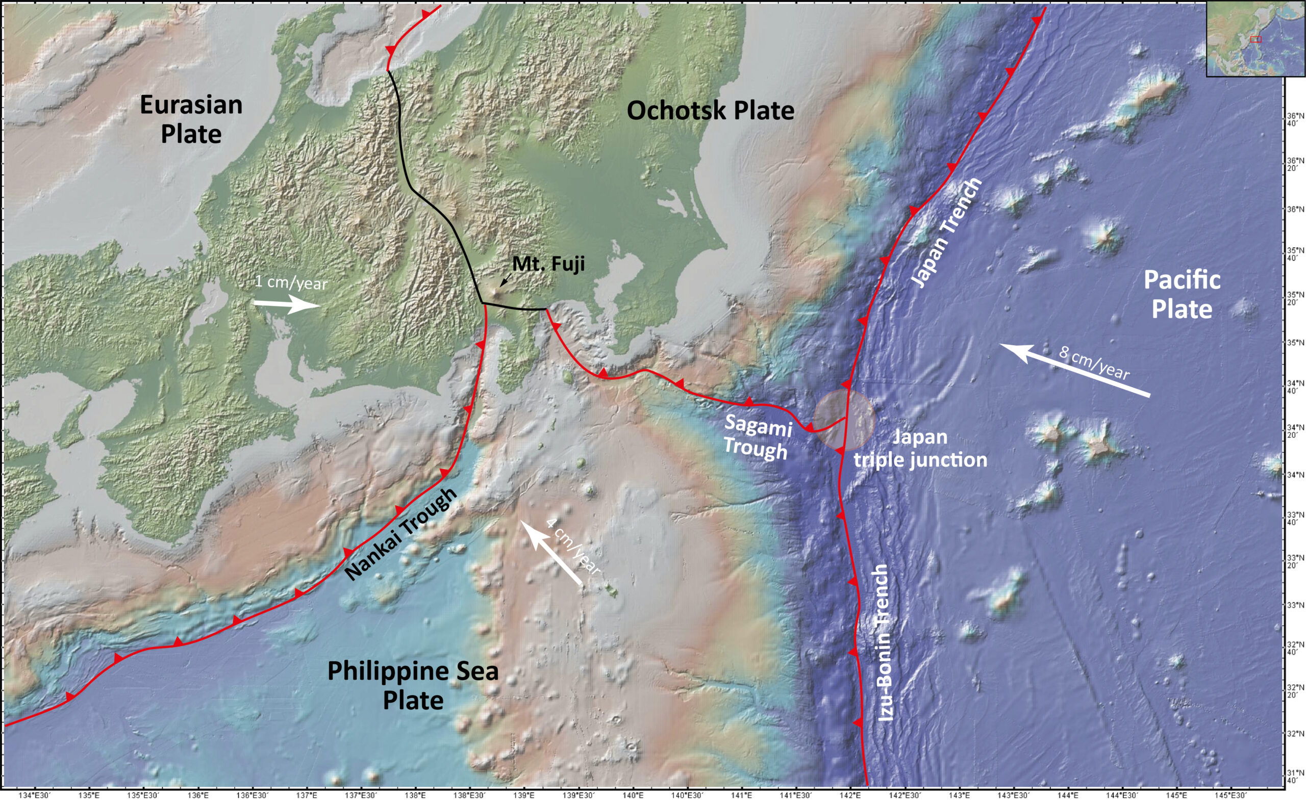
Fig. 4.5.5a: TTT triple junction – example Japan triple junction, Pacific coast off Japan (topographic/bathymetric map 2024 created with GeoMapApp / CC BY / CC BY (Ryan et al., 2009).
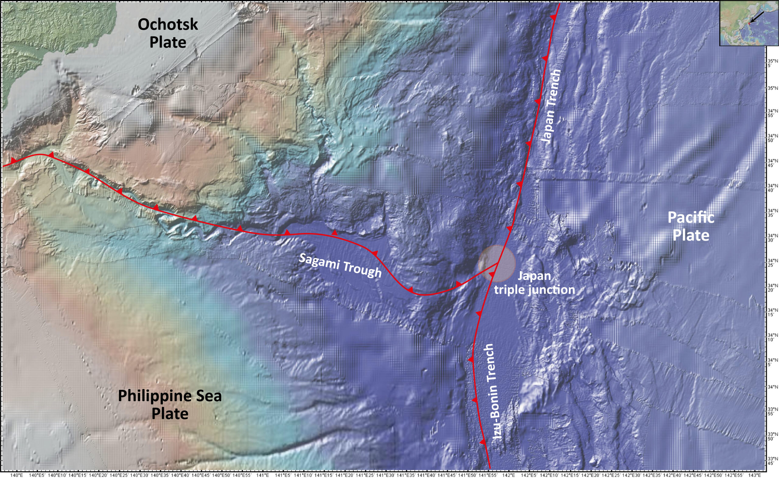
Fig. 4.5.5b: Detailed bathymetric map of the Japan triple junction, Pacific coast off Japan (topographic/bathymetric map 2024 created with GeoMapApp / CC BY / CC BY (Ryan et al., 2009).
Three subduction zones meet off the Japanese Pacific coast, the Japan Trench in the north, the Izu-Bonin Trench in the south and, extending to the west, the Sagami Trough (Fig. 4.5.5a). This is a TTT triple point.
The trace of the Sagami subduction zone and the exact meeting point of the three subduction zones is not entirely clear in detail (Fig. 4.5.5b).
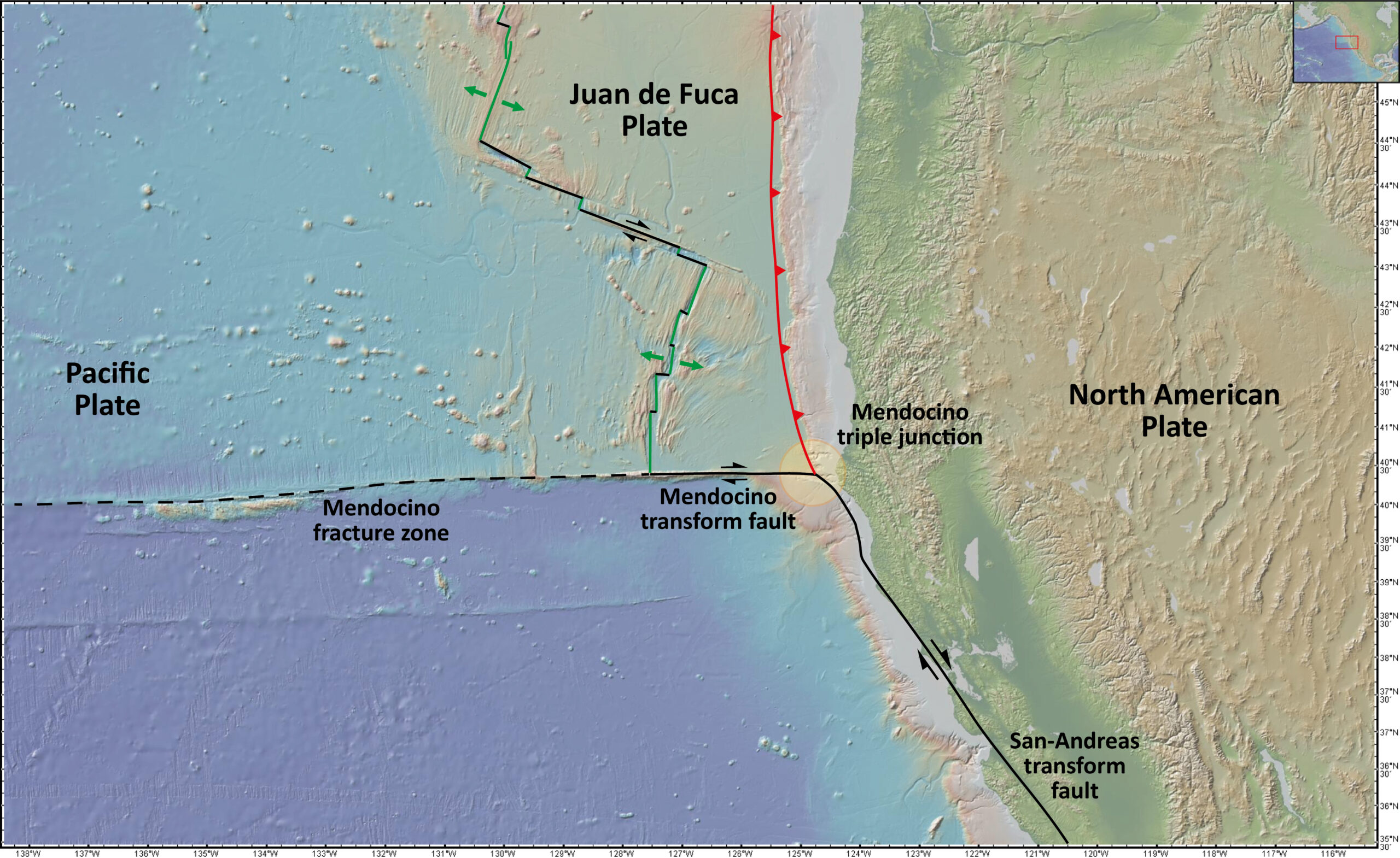
Fig. 4.5.6a: TFF triple junction – example Mendocino triple junction, western coast of North America, off California (topographic/bathymetric map 2024 created with GeoMapApp / CC BY / CC BY (Ryan et al., 2009).
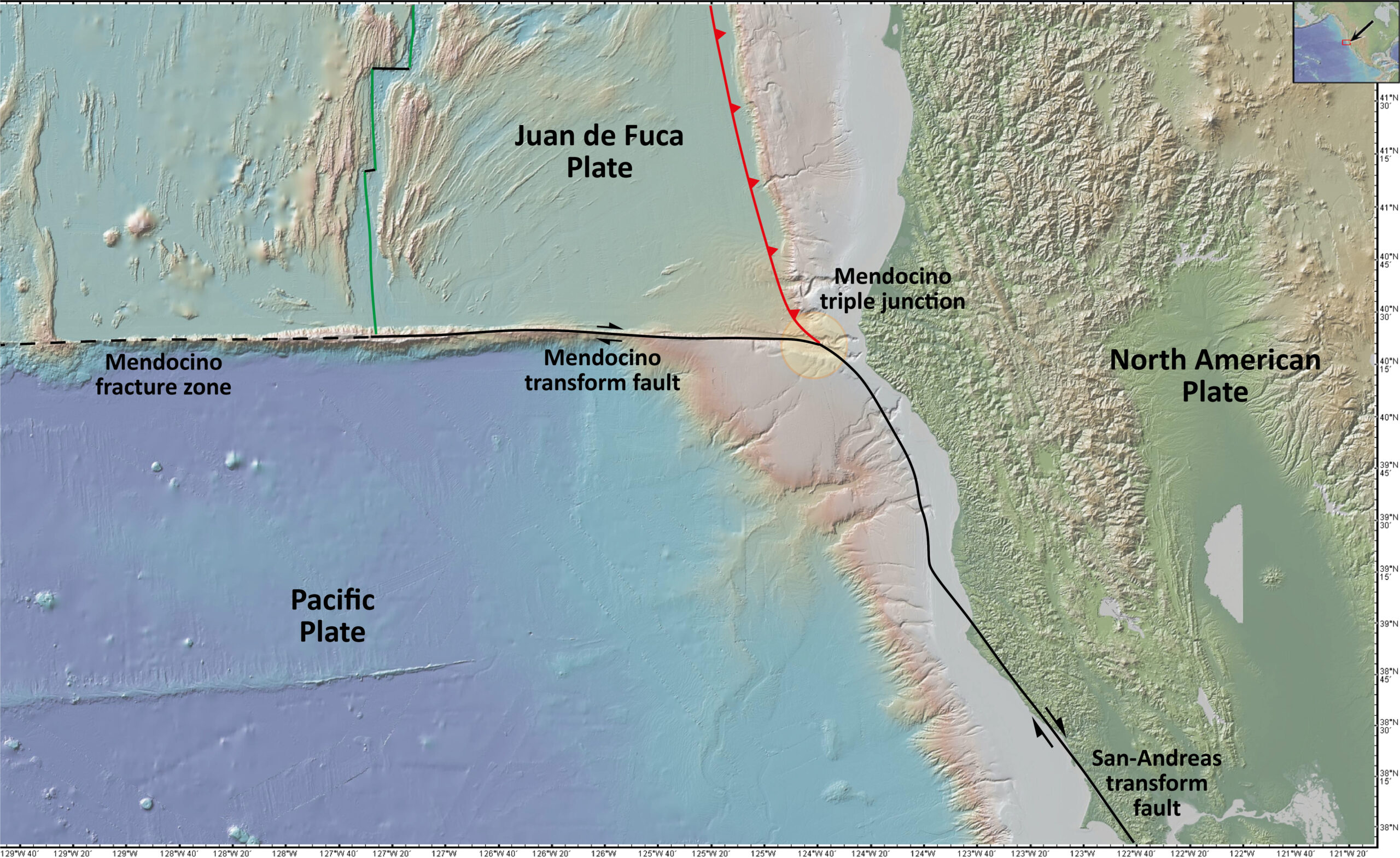
Fig. 4.5.6a: Detailed topographic/bathymetric map of the Mendocino triple junction, western coast of North America, off California (topographic/bathymetric map 2024 created with GeoMapApp / CC BY / CC BY (Ryan et al., 2009).
At the southern end of the Juan de Fuca plate in the northeastern Pacific Ocean is a TFF triple junction, where two transform faults and a subduction zone meet: the Cascadia subduction zone to the north, the San Andreas transform fault to the south and, to the west, the Mendocino transform fault (Fig. 4.5.6a).
The exact location of the triple junction is not clear in the detailed view (Fig. 4.5.6b). The trace of the San Andreas Transform Fault is obscured by young sediments on the shelf off the North American west coast.
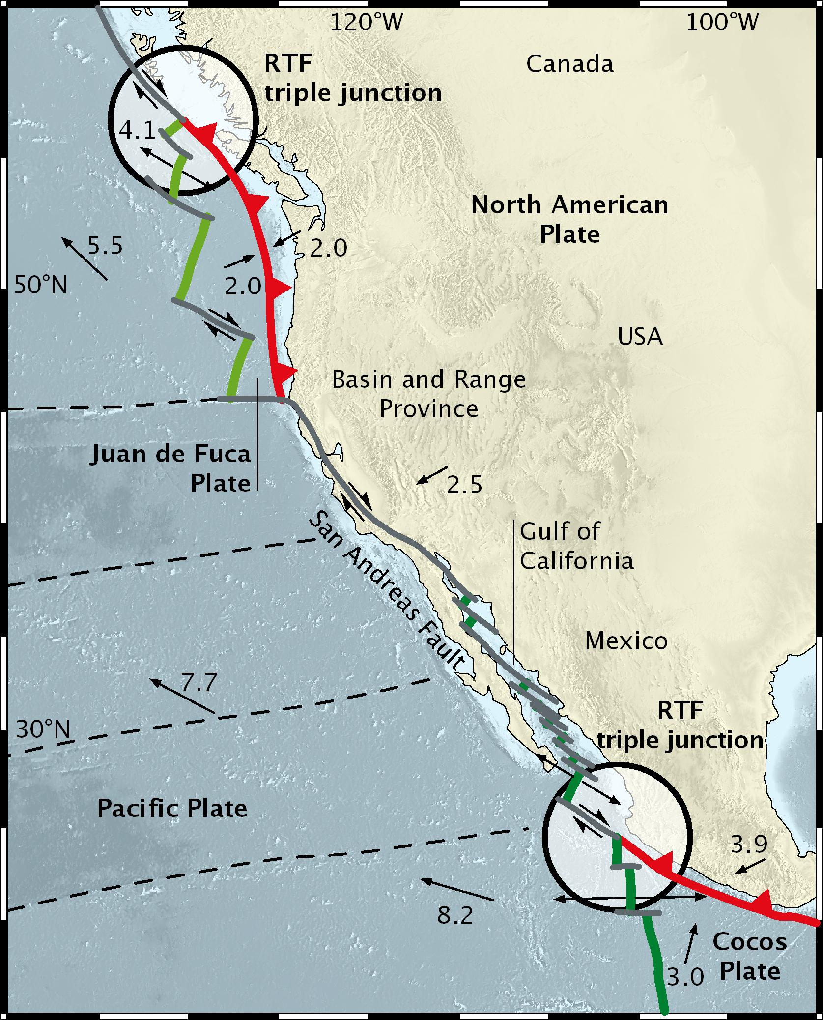
Fig. 4.5.7a: RTF triple junction off the west coast of North America (from Frisch, Meschede and Blakey, 2021).
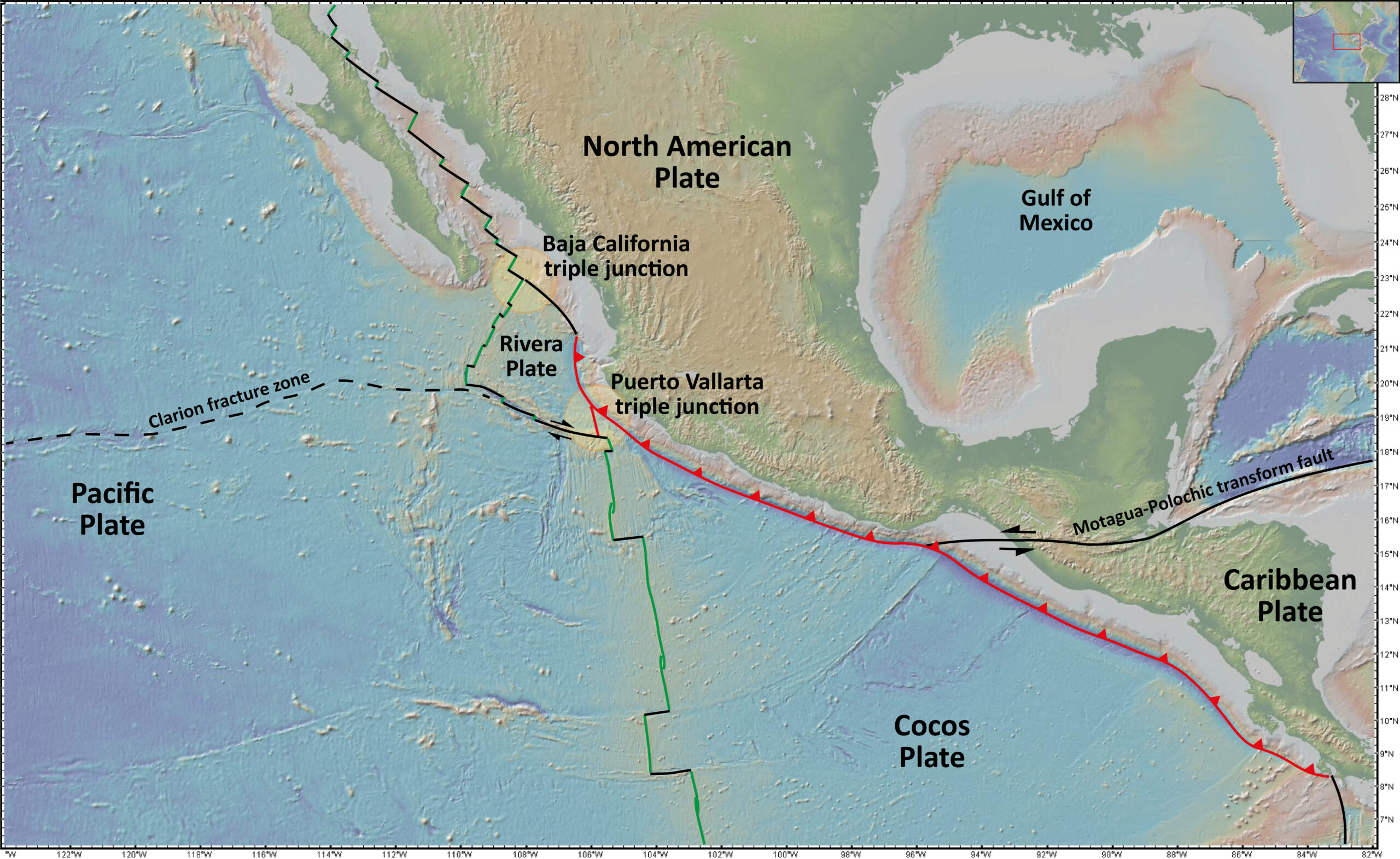
Fig. 4.5.7b: RTF triple junction – example Baja-California triple junction, western coast of North America, at the entrance of the Gulf of California (topographic/bathymetric map 2024 created with GeoMapApp / CC BY / CC BY (Ryan et al., 2009).
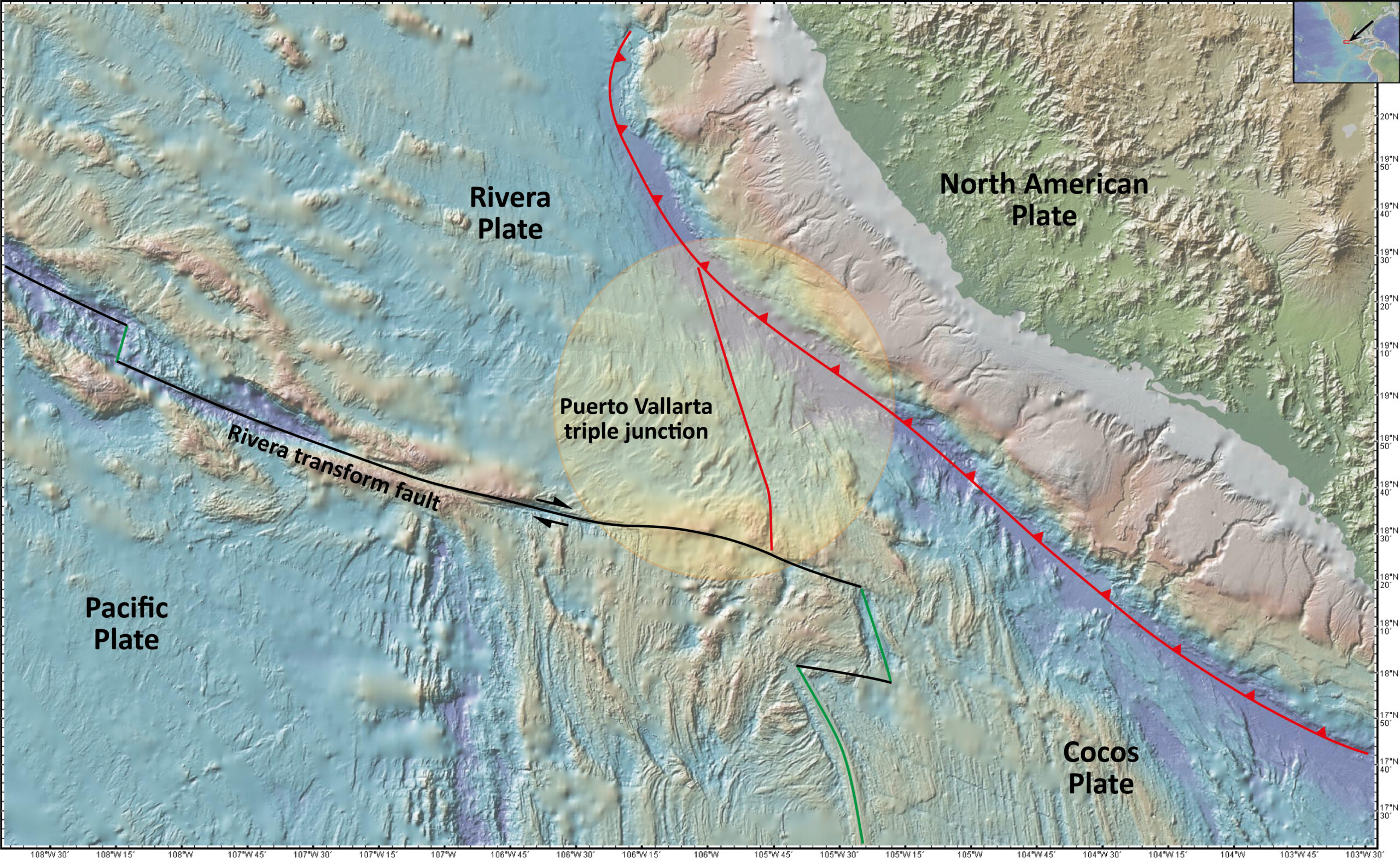
Fig. 4.5.7c: Detailed bathymetric map of the Baja-California triple junction at the entrance of the Gulf of California (topographic/bathymetric map 2024 created with GeoMapApp / CC BY / CC BY (Ryan et al., 2009).
In Fig. 4.5.7a two examples of RTF triple junctions are shown on the west coast of North America. At a RTF triple junction a mid-oceanic ridge meets a subduction zone and a transform fault. Viewed from a distance, the southern triple junction in Fig. 4.5.7a actually appears to be an RTF triple point.
However, if you look more closely (Fig. 4.5.7b), the situation becomes much more complicated. The East Pacific Rise is not in contact with the subduction zone, but is offset to the west along a transform fault slightly in front of the subduction zone and only then passes north into the Gulf of California. The subduction zone, on the other hand, continues a little further to the west and then also merges into a transform fault. As a result, a small microplate, the Rivera plate, was formed here.
Between the subduction zone and the East Pacific Rise the situation is somewhat indifferent, as can be seen from the detailed bathymetric map (Fig. 4.5.7c). The connection between the Rivera transform fault and the subduction zone is not clear. It is interpreted as a convergence zone with a slight compressive component, but a subduction zone is not formed here.
Triple junctions on Earth
Absolute and relative plate motion (in prep.)


![]()
©2022 Deutsche Geologische Gesellschaft - Geologische Vereinigung